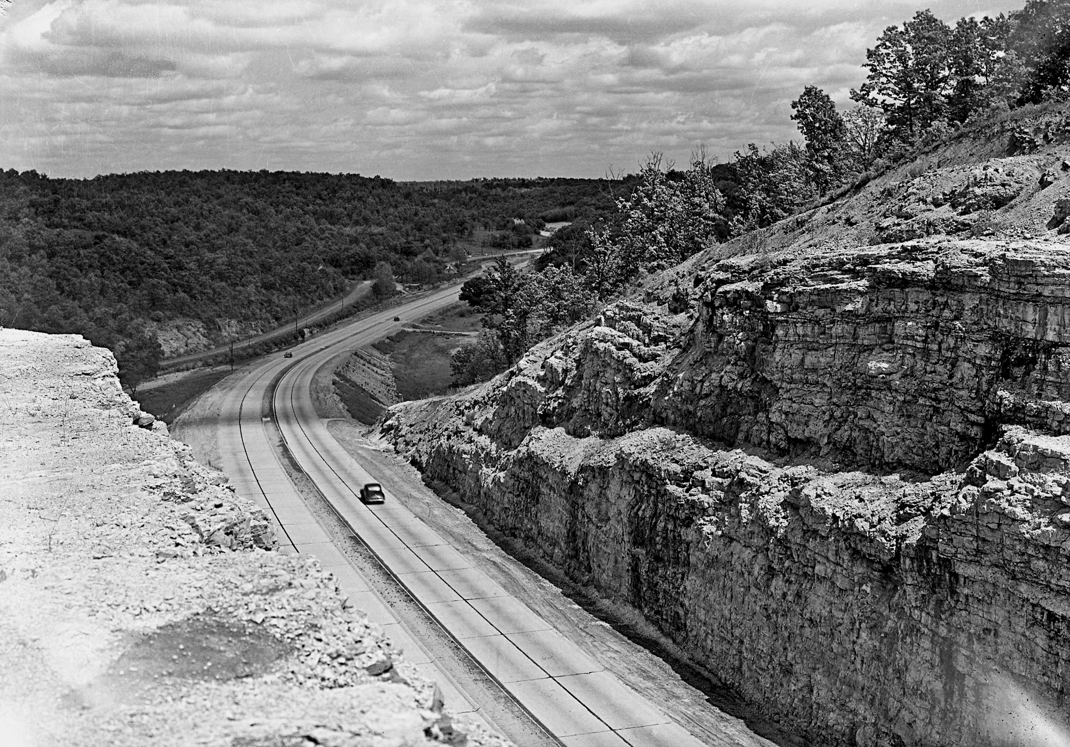
![Hooker Cut as it looked upon completion in 1945. This view is looking east on Route 66. [Courtesy of Missouri State Archives, Missouri Department of Transportation Collection]](/sites/default/files/styles/article_header_image/public/2025-04/1.-hooker-cut.jpg?itok=dhAd3zbv "Hooker Cut as it looked upon completion in 1945. This view is looking east on Route 66. [Courtesy of Missouri State Archives, Missouri Department of Transportation Collection]")
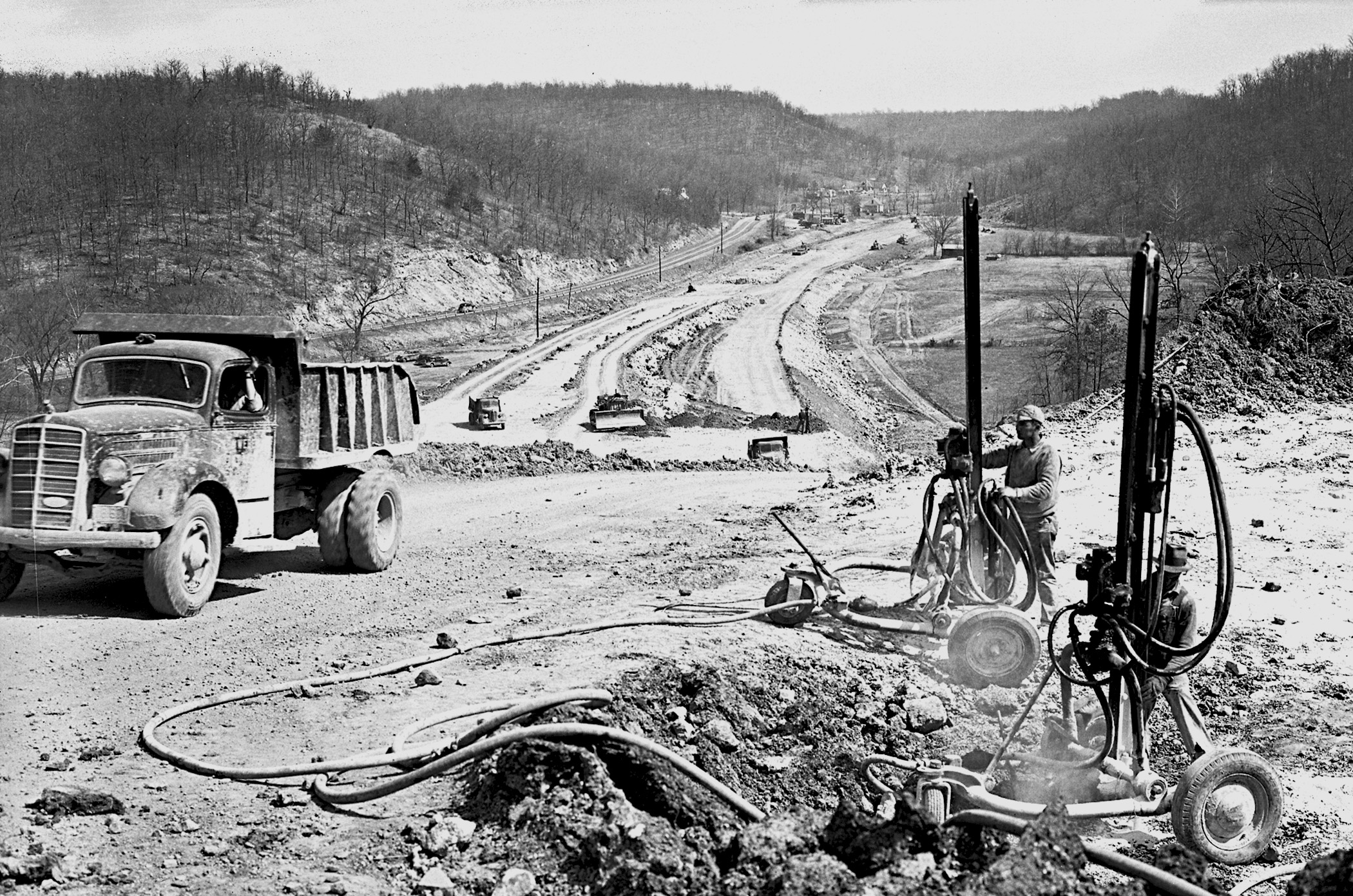
![Steam drills fracture rock for removal from the roadbed. [Courtesy of Missouri State Archives, Missouri Department of Transportation Collection]](/sites/default/files/styles/article_header_image/public/2025-04/2.-hooker-cut.jpg?itok=fGWtZQGm "Steam drills fracture rock for removal from the roadbed. [Courtesy of Missouri State Archives, Missouri Department of Transportation Collection]")
![A detail from the 1944 official state highway map showing Route 66 and State Highway 17 intersecting in Pulaski County near Fort Leonard Wood. [Missouri Department of Transportation, Missouri Highway Map Archive, 1918–2019]](/sites/default/files/styles/article_header_image/public/2025-04/3.-hooker-cut.jpg?itok=p3iWLxnq "A detail from the 1944 official state highway map showing Route 66 and State Highway 17 intersecting in Pulaski County near Fort Leonard Wood. [Missouri Department of Transportation, Missouri Highway Map Archive, 1918–2019]")
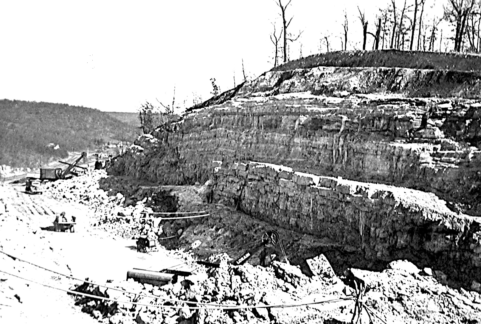
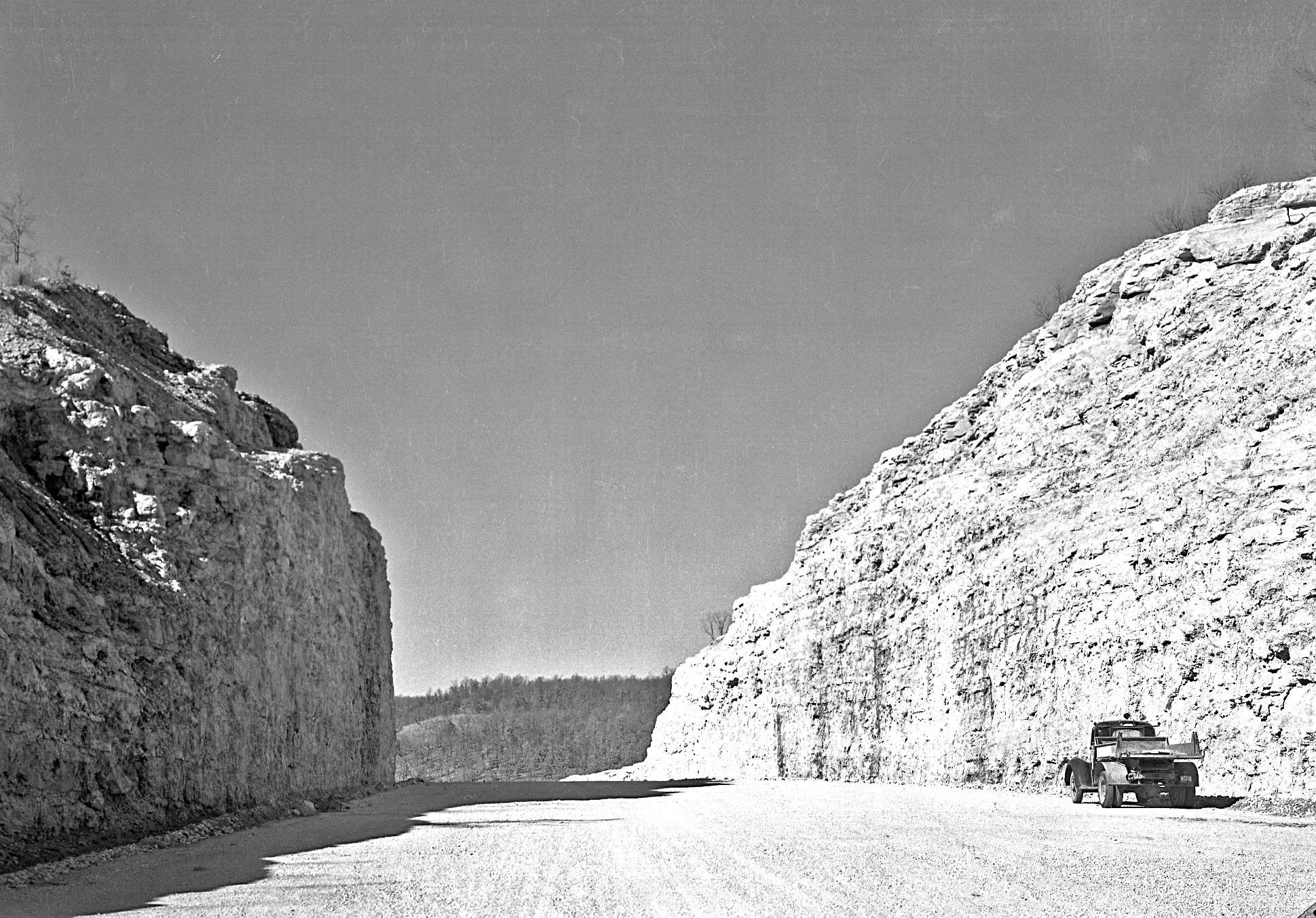
![Terracing for Hooker Cut went thirty feet up and fifteen feet back from the road, allowing loose rock to fall on the flat terraces or extra-wide shoulders. [Courtesy of Missouri State Archives, Missouri Department of Transportation Collection]](/sites/default/files/styles/article_header_image/public/2025-04/4.-hooker-cut.jpg?itok=FXQz8yiI "Terracing for Hooker Cut went thirty feet up and fifteen feet back from the road, allowing loose rock to fall on the flat terraces or extra-wide shoulders. [Courtesy of Missouri State Archives, Missouri Department of Transportation Collection]")
![The unpaved cut in 1944. [Courtesy of Missouri State Archives, Missouri Department of Transportation Collection]](/sites/default/files/styles/article_header_image/public/2025-04/5.-hooker-cut.jpg?itok=RtTcKslV "The unpaved cut in 1944. [Courtesy of Missouri State Archives, Missouri Department of Transportation Collection]")
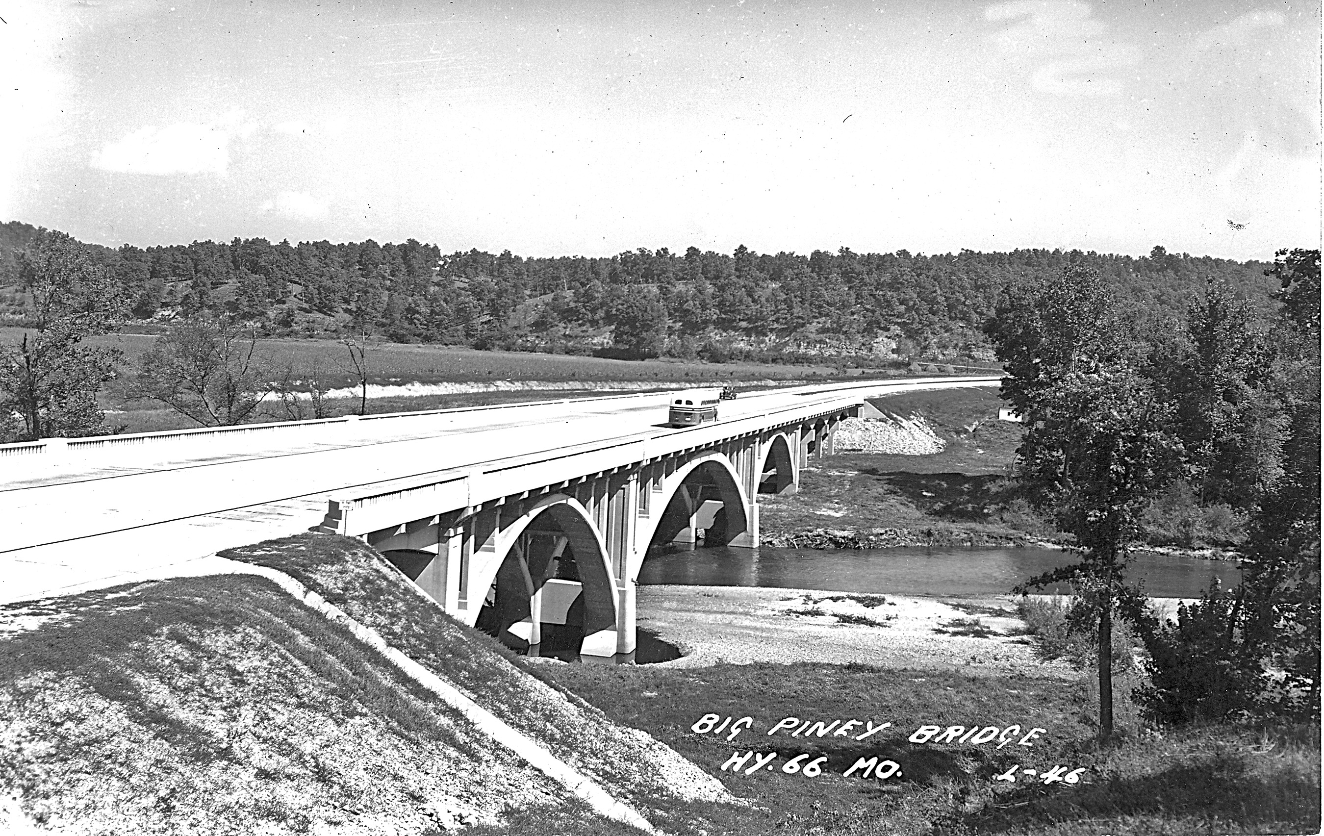
![The new concrete arch bridge over the Big Piney River, completed in 1945. [Courtesy of Missouri State Archives, Missouri Department of Transportation Collection]](/sites/default/files/styles/article_header_image/public/2025-04/6.-hook-cut.jpg?itok=dHf_k2ks "The new concrete arch bridge over the Big Piney River, completed in 1945. [Courtesy of Missouri State Archives, Missouri Department of Transportation Collection]")
By the middle of 1940, Europe was engulfed in war. On September 16, Franklin D. Roosevelt signed legislation authorizing selective service registration in the United States. A month later, more than sixteen million men, ages twenty-one to thirty-five, registered for the country’s first peacetime draft, a conscription described by President Roosevelt as “a program obviously of defensive preparation and of defensive preparation only.” US Secretary of War Henry L. Stimson stated that induction would start in November and six hundred thousand men would enter the armed forces by March 5, 1941. It would be necessary to build forty-six new training camps to train and equip the army of 1.4 million men that conscription mandated.
In November of 1940, land acquisition began for a military training camp in south-central Pulaski County, Missouri. When construction began in January of 1941, thirty-two thousand workers flooded the rural county. Because good transportation by rail and road were perquisites for the camp, which was planned to house thirty thousand soldiers, the site chosen for what became Fort Leonard Wood was close to a federal highway, Route 66. However, Route 66 soon proved inadequate for the increased road traffic to the military base, particularly through the eastern part of the county. To improve the highway, engineers needed to blast a new roadbed through an imposing limestone ridge. Hooker Cut, as the project came to be known, resulted in the deepest road cut yet made on Route 66 or any other road in the United States.
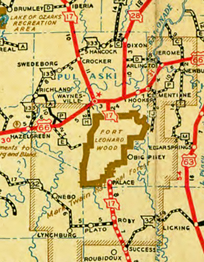
State Highway 17 South, a gravel road, was the main route running directly through the US Army camp site. It bisected Fort Leonard Wood’s seventy thousand acres from north to south on its way to Houston in Texas County. Highway 17 intersected Route 66 at a junction locally called the Wye. In 1939, the Missouri State Highway Department did a traffic count just west of the Wye. The twenty-four-hour count noted 1,833 vehicles. Between February 12 and 15, 1941, with more than half of the camp’s workforce yet to be employed, the count was 11,148 vehicles. As the number of laborers increased, traffic became bumper to bumper at the beginning and end of the workday. By April, the highway had surpassed its capacity. Realizing that the federal highway would hamper military traffic when the soldiers arrived, military and state engineers began planning improvements.
The US Defense Department put Works Progress Administration enrollees to work constructing a four-mile, four-lane divided highway from the Wye to the military cantonment area. Improvements to Route 66 from the Phelps County line west to the Wye posed greater difficulties. The original Route 66 from near the Phelps County line through Devils Elbow in Pulaski County had never been paved, due to a proposed dam on the Gasconade River that would have backed up the Big Piney River and inundated the area.
In addition to the road through Hooker and Devils Elbow being gravel and not suitable for heavy military traffic, the road itself was very narrow. As most early roads did, it followed the contours of the land, either along a ridgetop or following a valley and stream. The western end made a sweeping curve around a high ridge past Wagon Ford, where military wagon trains and early automobiles forded the Big Piney River until a steel bridge was built at Devils Elbow in 1923. The bridge had a curve on the northern end that caused problems for large trucks and machinery. Its steel superstructure also had a height restriction of thirteen feet. A new bridge west of the cut would remove these two limitations.
The engineers drafted a bold plan for the highway’s approach to the bridge from the east. Instead of going around the high ridge at Hooker, they proposed to straighten and widen the road by cutting through the ridge. To increase the vehicular capacity, they envisioned a four-lane divided highway—the first such stretch of road on Route 66 in Missouri. Furthermore, the highway cut through the ridge would require the deepest road cut in the country at the time. Both the cut and the divided highway would employ several innovations in road building.
Bids were solicited on August 28, 1941, for improving Route 66. The proposed work included “grading, constructing culverts, and producing crushed stone for coarse aggregate, together with any incidental work, on the above State road from the Big Piney River east through Hooker Hill cut, the total length of the improvement being 1.038 miles.” As with all proposals issued by the state highway department in this era, it contained a statement that “the minimum wage to be paid all labor employed on this contract shall be as follows: Skilled Labor—80c per hour; Intermediate Grade Labor—50c per hour; Unskilled Labor—40c per hour.”
The project at Hooker required a ninety-two-foot cut through a limestone ridge to straighten the path of Route 66 in Pulaski County. A press release from the Missouri State Highway Department on September 10, 1941, reported that “this will be the deepest cut ever attempted on the state highway system and will include an estimated 280,000 cubic yards of excavation and will produce some 87,000 tons of crushed aggregate for concrete paving. The grading will be through Hooker Hill . . . It has attained importance as a national defense highway because of the nearness to Fort Leonard Wood. The project will require over six months of work to complete and is being done to provide needed material for concrete masonry and pavement aggregate for other proposed construction on the Route, as well as provide a desirable improvement on 66 over this distance.” Despite the Highway Department’s report, however, the excavated limestone proved unsuitable for use in concrete.
Fred Weber Construction of St. Louis was awarded the contract in September on the slightly more than one mile of highway construction for the low bid of $244,889.13. The roadwork was given additional importance with the passage of the Defense Highway Act of 1941 in November. After Pearl Harbor on December 7, federal highway projects were restricted to those certified as essential in carrying on the war, which included the removal of highway bottlenecks to camps, munitions plants, and shipyards. However, the “over six months” proved to be a very elastic estimation of the construction time required, regardless of the priority given the project. Material, manpower, and equipment shortages lengthened it considerably.
Joining the new route of the highway through Hooker Cut to the new location of Route 66 to be laid just north of the existing two-lane from Morgan Heights to near Waynesville required another project: a “superbridge” across the Big Piney River. Additionally, 2.126 miles of connecting pavement were needed from Highway 28 near Morgan Heights to Hooker Cut.
At the end of June 1942, the State Highway Department announced that the O’Dell and Rinney construction firm of Hannibal, Missouri, had won the contract for the 2.126-mile connecting pavement with a bid of $393,930.63. The department also announced that it had received no bids for the bridge construction. The local paper guessed that the bridge “will probably be built on a cost-plus basis.”
In August, contracts were let for the remaining improvements to the east of Waynesville. O’Dell and Rinney received the go-ahead for 4.699 miles of Portland Cement Concrete (PCC) pavement and a bridge over Hooker Branch and through Hooker Cut. The low bid (maybe the only one) of $273,147.40 gave the project of building a new bridge over the Big Piney to Hannibal Contracting Company of Hannibal.
The route was fixed and contracts awarded for the superhighway from just west of Powellville in Phelps County to within a mile or so of Waynesville. As World War II raged, it claimed resources of cement, steel for rebar, workers, and engineers. The delays caused by shortages required some sections to be rebid later and some pavement to be finished by a contractor other than the original low bidder. The Hooker Cut improvement was finally completely open to traffic in September of 1945, the month the war ended with Japan’s surrender. Fort Leonard Wood, the impetus for the project, was closed and relegated to stand-by status six months later, though it reopened in 1950 at the start of the Korean War.
The new four-lane highway had the desired effect of moving more traffic in a much faster manner. The new road bypassed the Hooker neighborhood, which was part of an area known to tourists as Basketville. It had eight mom-and-pop businesses selling handcrafted Ozark souvenirs, such as oak baskets and hickory chairs, and several offered cabin camp accommodations. Tourists traveling the gravel road at twenty miles per hour got a good look at the roadside wares. Travelers driving faster on the four-lane, however, barely noticed the attractions, which gradually went out of business. Only one family business moved to the new road. Hooker Cut became the tourist attraction—and still is.
The new road brought some innovations to highway engineering. The steep and deep ninety-two-foot cut required the terracing of the cut’s walls, thirty feet up and fifteen feet back. Falling rock landed on the terraces or wide shoulders. The two twenty-two-foot concrete slabs were separated by a raised, grassy median, and the edges of the highway had a curb which guided water into culverts for diversion away from the road.
The highway through Hooker Cut was the first divided four-lane to open on Route 66 in Missouri and the last to close when that section of I-44 was completed in 1979. It is still in use today for local traffic and for the nostalgic Route 66 road enthusiast.
Primas, Terry. From Village to Town: Waynesville, Missouri, 1941–1946. Duke, MO: Big Piney Productions, 2022.
———. Route 66 in Pulaski County, Missouri: A Local History. Duke, MO: Big Piney Productions, 2017.
Scott, Quinta, and Susan Croce Kelly. Route 66: The Highway and Its People. Norman: University of Oklahoma Press, 1988.
Published April 7, 2025; Last updated September 26, 2025
Creative Commons Attribution-NonCommerical-ShareAlike 4.0 International (CC BY-NC-SA 4.0)