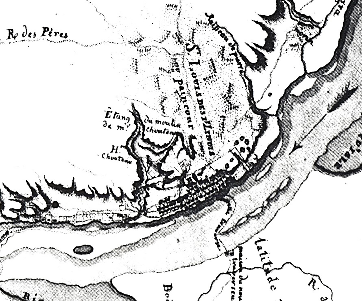
![A detail from the Finiels map of the Mississippi River showing the area around St. Louis. The original is in the Archives de la Marine, Chateau, Vincennes, France. [Courtesy of Carl J. Ekberg]](/sites/default/files/styles/article_header_image/public/2023-07/1.%20Nicolas%20de%20Finiels.jpg?h=198c041c&itok=zTGl8JJc "A detail from the Finiels map of the Mississippi River showing the area around St. Louis. The original is in the Archives de la Marine, Chateau, Vincennes, France. [Courtesy of Carl J. Ekberg]")
Nicolas de Finiels, an expatriate French engineer who served the Spanish monarchy during the late colonial era, remains little known. Yet he enjoys the distinction of having prepared two of the most valuable source documents pertaining to Upper Louisiana in colonial times: a lengthy memoir titled An Account of Upper Louisiana and a meticulously drawn map of the central Mississippi River valley. The forty-thousand-word account provides important information about Upper Louisiana in the late 1790s on subjects ranging from geopolitics to details of domestic life. The map, undeniably the best ever created of the eighteenth-century Illinois Country, complements Finiels’s text with a careful rendering of both physical and cultural features of the Mississippi valley from the mouth of the Illinois River south to the outpost of New Madrid.
There is no direct evidence concerning Finiels’s exact place and date of birth, his education, or the circumstances that prompted him to leave France. The best guess is that Finiels, a sharp critic of the French Revolution, was one of the numerous political refugees who came to the United States during the early 1790s. The earliest documented account places him in Philadelphia in 1797, where he made the acquaintance of Carlos Martinez de Irujo, the Spanish minister to the United States. Irujo had launched a major campaign to improve the dilapidated military fortifications in St. Louis. The French agent-general Georges-Victor Collot met Finiels and Irujo in Philadelphia and shared with them impressions about Louisiana gained during his recent travels. Seeking to pass himself off as a friend of the Spanish regime, he offered suggestions for improving St. Louis’s faulty defenses and suggested that Finiels be appointed to oversee such a project.
Without authorization from his superiors, Irujo retained Finiels as an engineer for the Spanish service and dispatched him to St. Louis. Finiels’s hostility to the French Revolutionaries and his open sympathy for the royal house of Bourbon evidently persuaded Irujo that he could be trusted with the assignment. Finiels arrived in St. Louis in early June 1797, accompanied by his wife and mother-in-law. During his stay in Philadelphia he had apparently met and married Marianne Rivière, a Creole from St. Domingue. Officials in Upper Louisiana received Finiels cautiously. Lieutenant Colonel Carlos Howard, the newly appointed Spanish military commander, was understandably hesitant to involve a stranger in the sensitive task of constructing military fortifications. Finiels suggested changes, but he was powerless to affect them without more explicit authorization from the Spanish government.
While he awaited a decision on his official status from Spanish administrators, Finiels reconnoitered Upper Louisiana’s settlements, gathered information about the region and its people, and put his talents as a draftsman to work. James MacKay, a prominent trader recently returned from leading an expedition up the Missouri River for the newly formed Company of Explorers of the Upper Missouri, made use of the temporarily out-of-work French engineer’s cartographic skills. In 1797 he employed Finiels to draft a map of the habitations located on the Missouri River near the Bon Homme Creek at a place later known as the District of St. André. That map, which Finiels referred to as “the latest map of the Missouri,” has mistakenly been confused with a Missouri River Map drawn by MacKay and subsequently used by Lewis and Clark. Finiels also struck up a friendship with the lieutenant governor, Zenon Trudeau, another French Creole in Spanish service. During the course of 1797–1798, Finiels, apparently on his own initiative, drafted his renowned map of the central Mississippi valley. Despite his frustrations, he was prepared to remain in St. Louis, but his plans were dashed in 1798 when he received word that the authorities in Madrid had rejected his appointment.
Finiels departed for New Orleans, where, despite the government’s pronouncement, Louisiana’s new governor, Manuel Gayoso de Lemos, decided to reemploy him. Finiels remained in New Orleans for the duration of the Spanish regime, working under Governor Gayoso and his successors on a vast array of projects, including drawing maps, repairing levees, planning fortifications, and even designing fire engines.
In 1800 Spain ceded Louisiana to France, and the French government named Pierre-Clement de Laussat to take charge of the province. Following his arrival in New Orleans in 1803, Laussat needed someone who was intelligent and literate, and who was knowledgeable about Upper Louisiana and willing to serve France. Nicolas de Finiels qualified on all counts. He was a royalist and a Roman Catholic, but his chronic financial problems and a lingering loyalty to France may have persuaded him to work for Laussat, even though he represented a revolutionary despot, Napoléon Bonaparte. It is unclear whether Laussat in fact hired Finiels to write his Account or whether the observant French engineer merely hoped to position himself for possible employment with the French regime by obliging Laussat. According to the notation on the manuscript, Finiels wrote his Account of Upper Louisiana in June 1803. A short time later the astounding news that France had agreed to sell Louisiana to the United States reached New Orleans, and the disappointed Laussat packed his bags and returned to France, taking along his copy of Finiels’s account and the original manuscript map of the Mississippi valley that Finiels had also prepared.
Following Louisiana’s transfer to the United States, Finiels cast his lot with Spain and remained in Spanish service. He participated in the 1805–1806 Spanish expedition into eastern Texas and drew an excellent map of that region. He was stationed successively at Havana and Pensacola. He bought property at the latter place and was wounded there during Andrew Jackson’s controversial 1818 raid into Spanish Florida. Finiels’s four sons followed their father into the Spanish army. The date of Finiels’s death is unknown.
Ekberg, Carl J., and William E. Foley, eds. An Account of Upper Louisiana by Nicolas de Finiels. Columbia: University of Missouri Press, 1989.
Wood, W. Raymond. “Nicolas de Finiels: Mapping the Mississippi and Missouri Rivers, 1797–1798.” Missouri Historical Review 81 (July 1987): 387–402.
Published July 13, 2023; Last updated July 25, 2023
Creative Commons Attribution-NonCommerical-ShareAlike 4.0 International (CC BY-NC-SA 4.0)