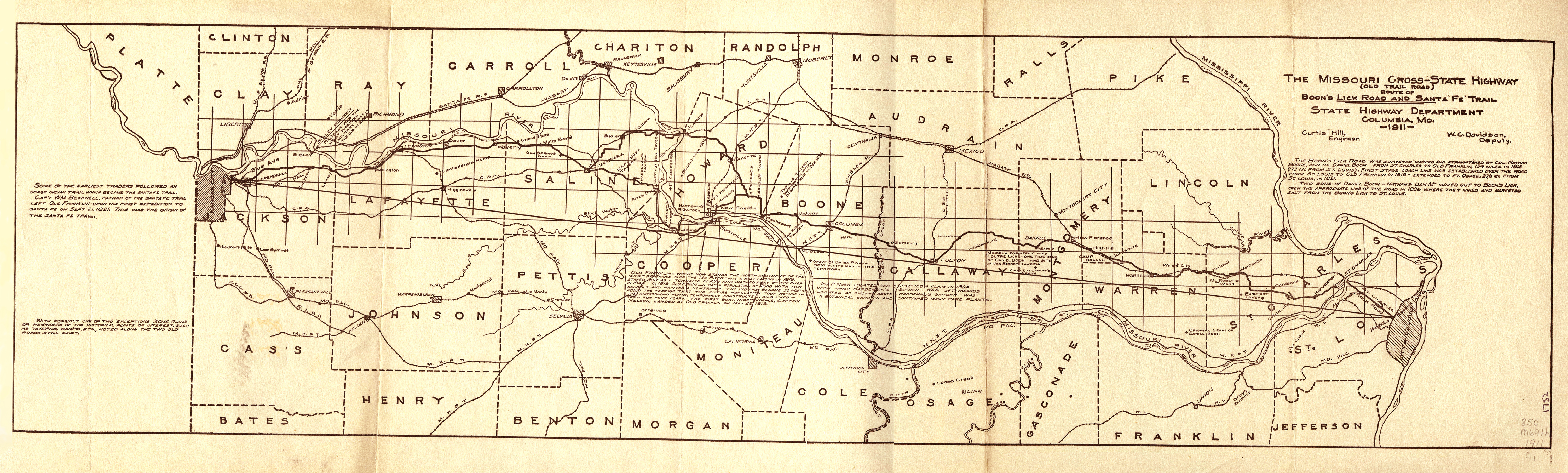
![A 1911 State Highway Department map of the Boone’s Lick Road and Santa Fe Trail. [State Historical Society of Missouri Map Collection, 850 M691h 1911]](/sites/default/files/styles/article_header_image/public/2024-05/1.-boones-lick-road.jpg?itok=KLOxhlwD "A 1911 State Highway Department map of the Boone’s Lick Road and Santa Fe Trail. [State Historical Society of Missouri Map Collection, 850 M691h 1911]")
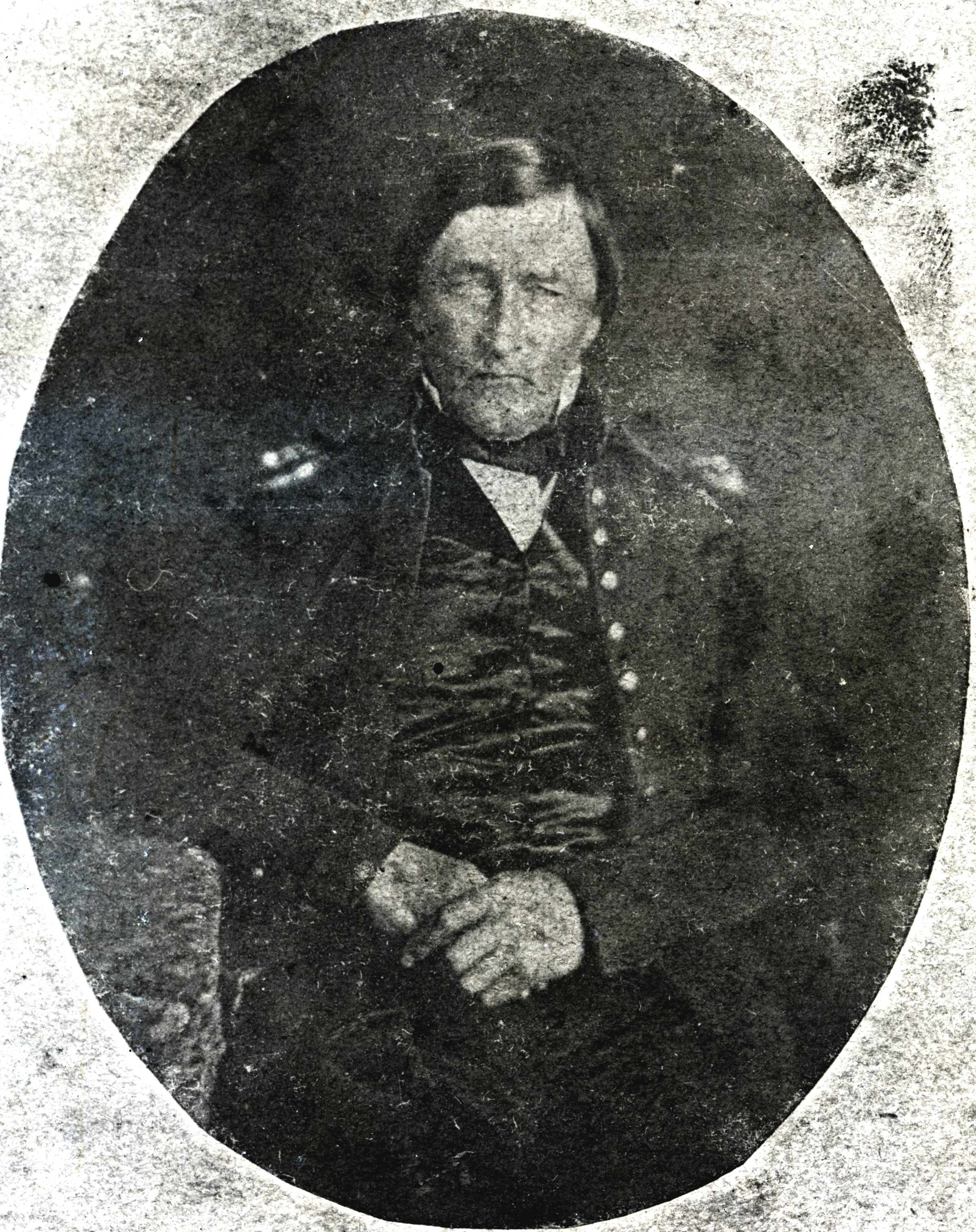
![Nathan Boone. The Boone family’s trail west to saltwater springs in what is now Howard County was the genesis for the Boone’s Lick Road. [State Historical Society of Missouri, R. L. Hosman Collection, P0925-018550]](/sites/default/files/styles/article_header_image/public/2024-05/2.-boones-lick-road.jpg?itok=FExfOVGd "Nathan Boone. The Boone family’s trail west to saltwater springs in what is now Howard County was the genesis for the Boone’s Lick Road. [State Historical Society of Missouri, R. L. Hosman Collection, P0925-018550]")
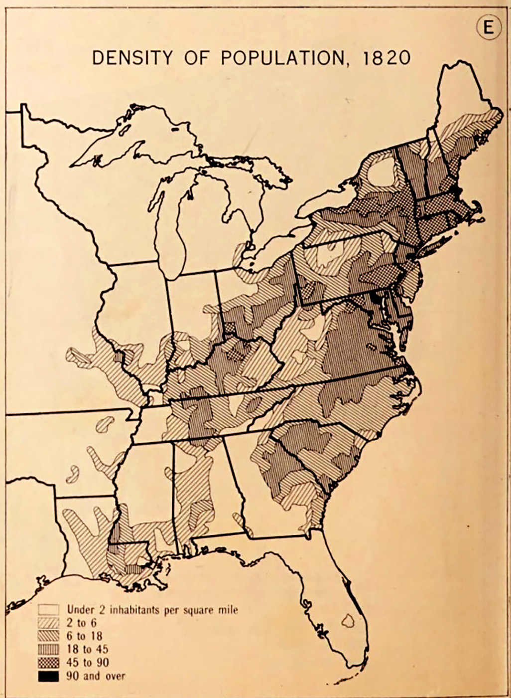
![This map of US population density in 1820 shows the flow of settlers into central Missouri along the Boone’s Lick Road. [Atlas of the Historical Geography of the United States, 1932]](/sites/default/files/styles/article_header_image/public/2024-05/3.-boones-lick-road.jpg?itok=VV3nlNJO "This map of US population density in 1820 shows the flow of settlers into central Missouri along the Boone’s Lick Road. [Atlas of the Historical Geography of the United States, 1932]")
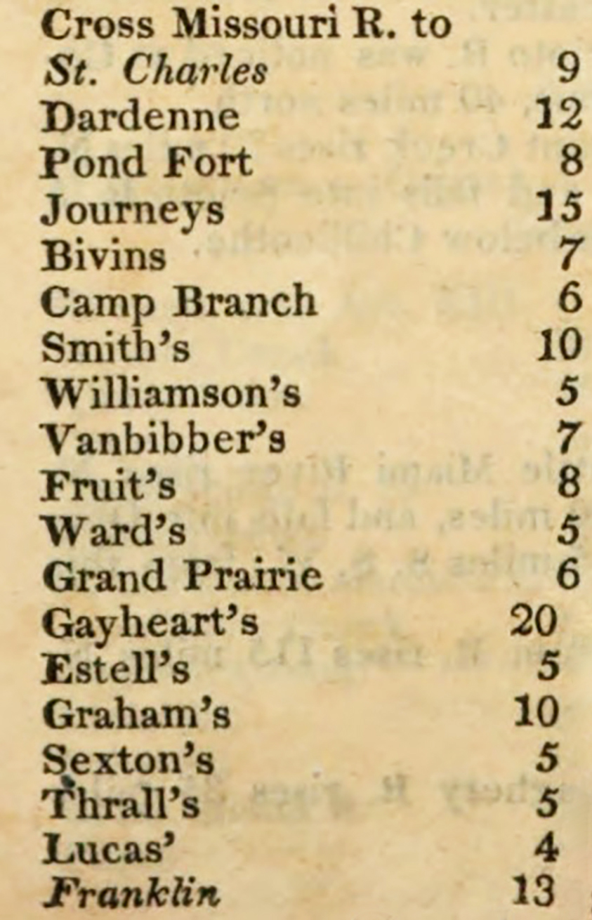
![A mileage chart of stops on the Boone’s Lick Road from an early nineteenth-century travel guide. [John Melish, The Traveller’s Directory through the United States, 1822]](/sites/default/files/styles/article_header_image/public/2024-05/4.-boones-lick-road.jpg?itok=XgpttisZ "A mileage chart of stops on the Boone’s Lick Road from an early nineteenth-century travel guide. [John Melish, The Traveller’s Directory through the United States, 1822]")
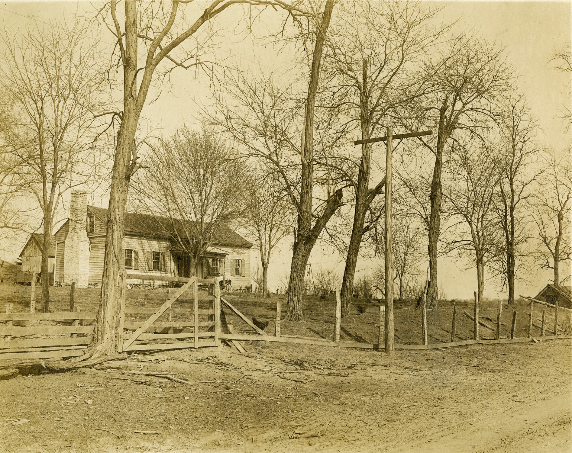
![Built in 1821, the Van Bibber Tavern in Loutre Lick (now Mineola), Montgomery County, was a stop on the Boone’s Lick Road. [State Historical Society of Missouri, J. S. Gregory Photographs, P0159-1]](/sites/default/files/styles/article_header_image/public/2024-05/5.-boones-lick-road.jpg?itok=hzvJeoXp "Built in 1821, the Van Bibber Tavern in Loutre Lick (now Mineola), Montgomery County, was a stop on the Boone’s Lick Road. [State Historical Society of Missouri, J. S. Gregory Photographs, P0159-1]")
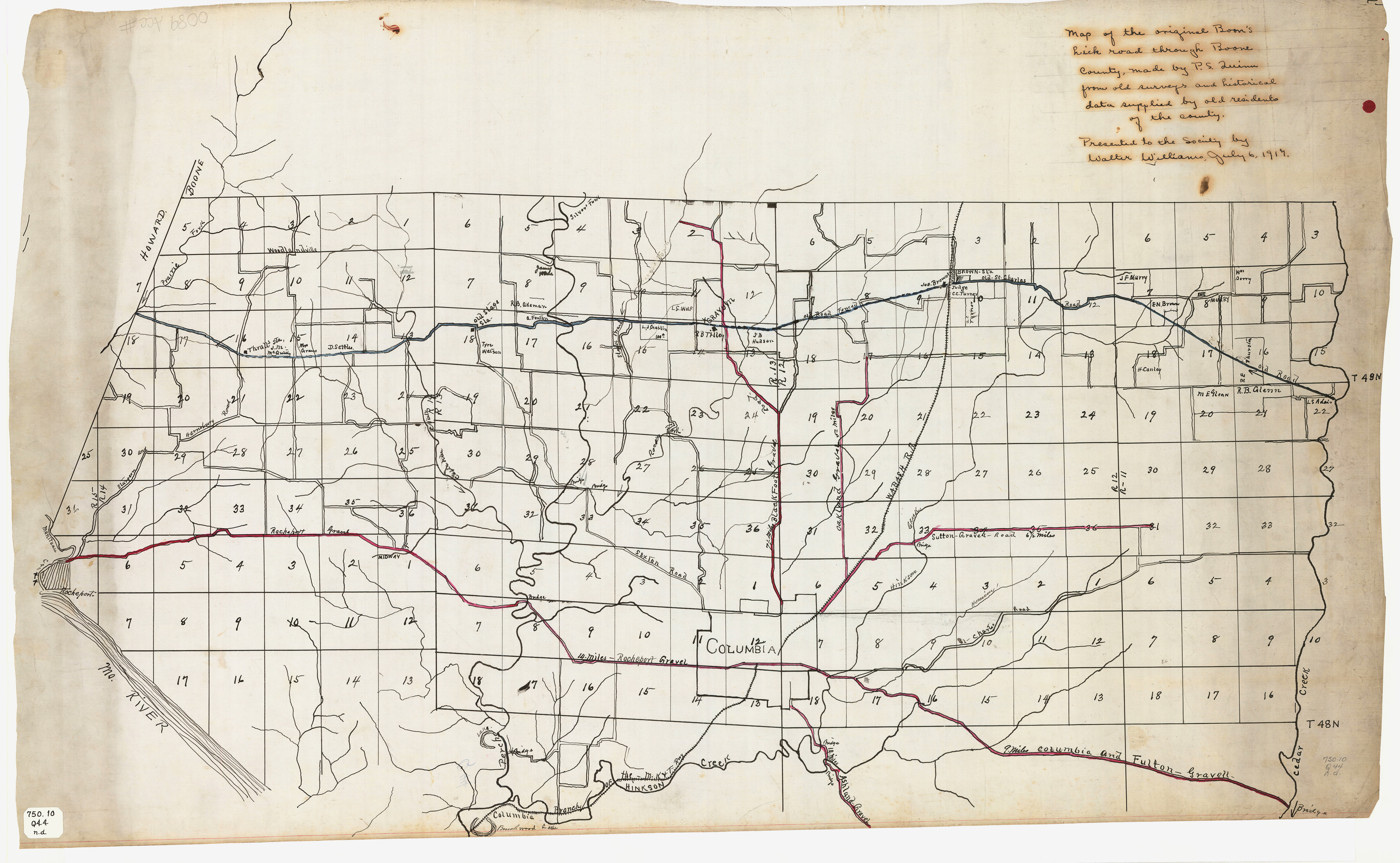
![A map of the Boone’s Lick Road through Boone County based on research by J. S. Quinn and presented to the State Historical Society of Missouri in 1917. [State Historical Society of Missouri Map Collection, 750.10 Q44 n.d.]](/sites/default/files/styles/article_header_image/public/2024-05/6.-boones-lick-road.jpg?itok=MgSUdIyH "A map of the Boone’s Lick Road through Boone County based on research by J. S. Quinn and presented to the State Historical Society of Missouri in 1917. [State Historical Society of Missouri Map Collection, 750.10 Q44 n.d.]")
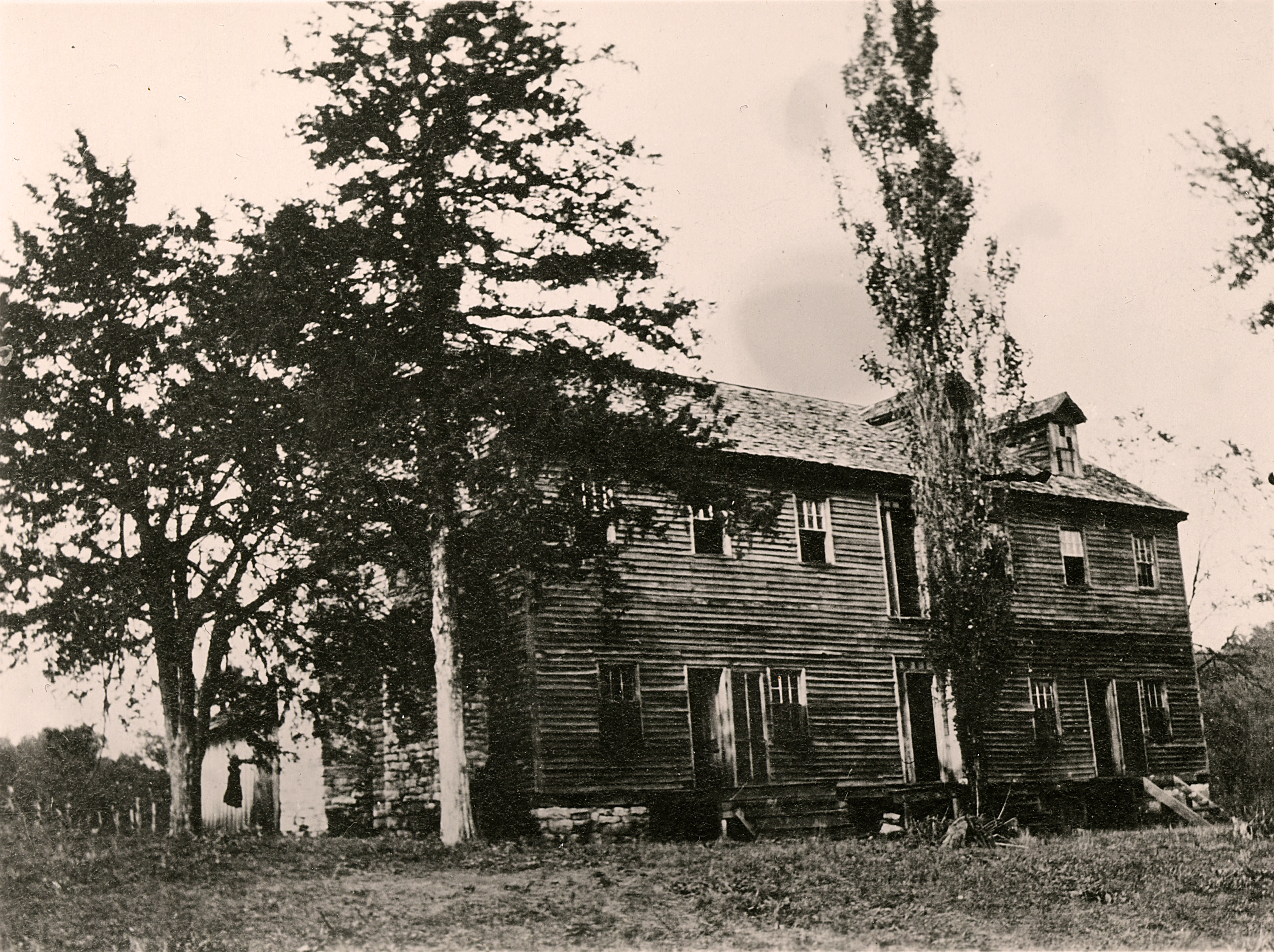
![An early twentieth-century photo of the Van Horn Tavern west of Columbia in Boone County. The tavern stood near its original location until 2013, making it the last known log tavern on the Boone’s Lick Road between St. Charles and Old Franklin. [State Historical Society of Missouri, Mrs. Lewis Sims Photograph Collection, P0324]](/sites/default/files/styles/article_header_image/public/2024-05/7.-boones-lick-road.jpg?itok=LnVs-JRv "An early twentieth-century photo of the Van Horn Tavern west of Columbia in Boone County. The tavern stood near its original location until 2013, making it the last known log tavern on the Boone’s Lick Road between St. Charles and Old Franklin. [State Historical Society of Missouri, Mrs. Lewis Sims Photograph Collection, P0324]")
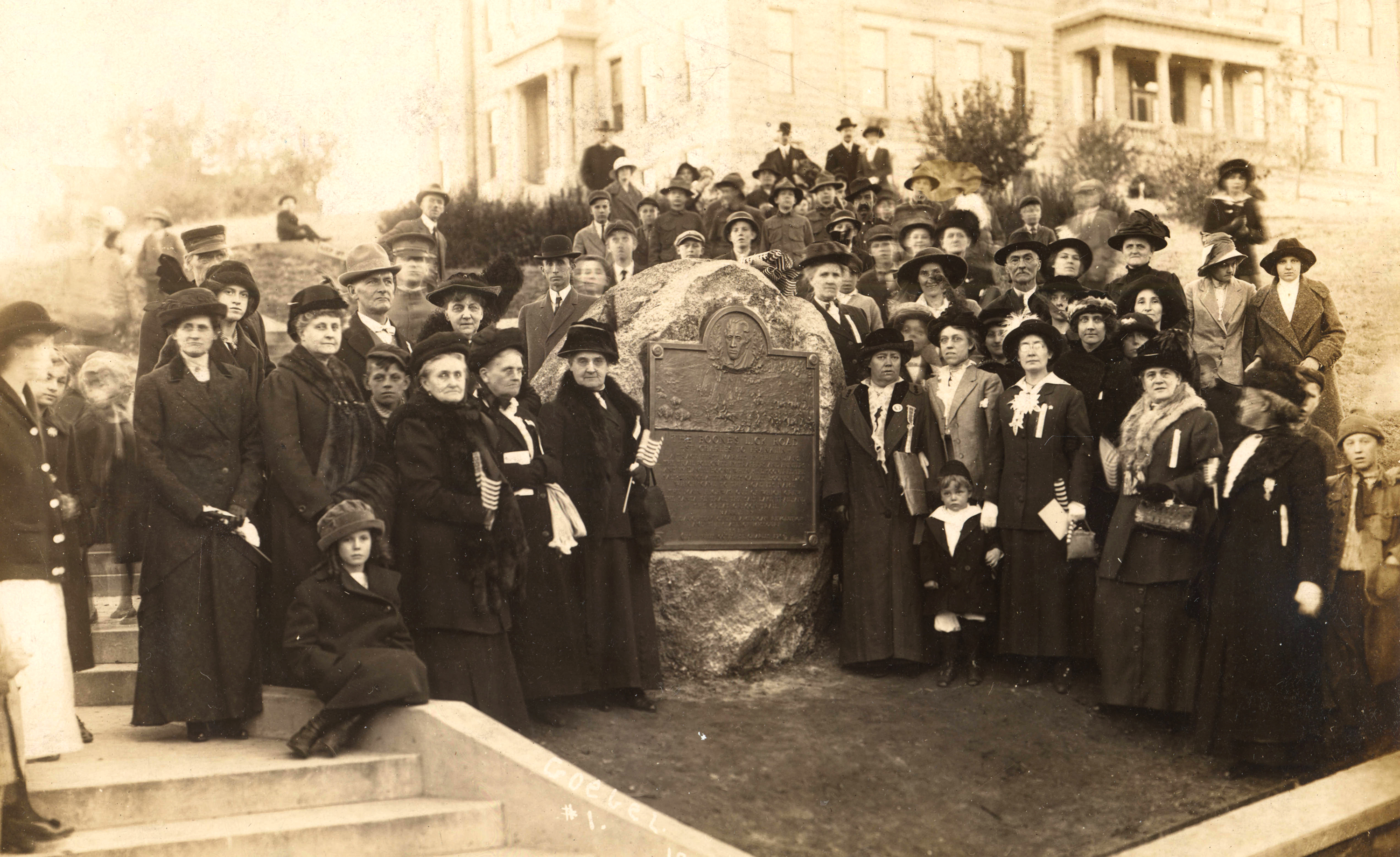
![Dedication of a Boone’s Lick Road marker in St. Charles by the Daughters of the American Revolution, 1913. [State Historical Society of Missouri, John J. Buse Collection, S1083-1110]](/sites/default/files/styles/article_header_image/public/2024-05/8.-boones-lick-road.jpg?itok=AhlAD9Zs "Dedication of a Boone’s Lick Road marker in St. Charles by the Daughters of the American Revolution, 1913. [State Historical Society of Missouri, John J. Buse Collection, S1083-1110]")
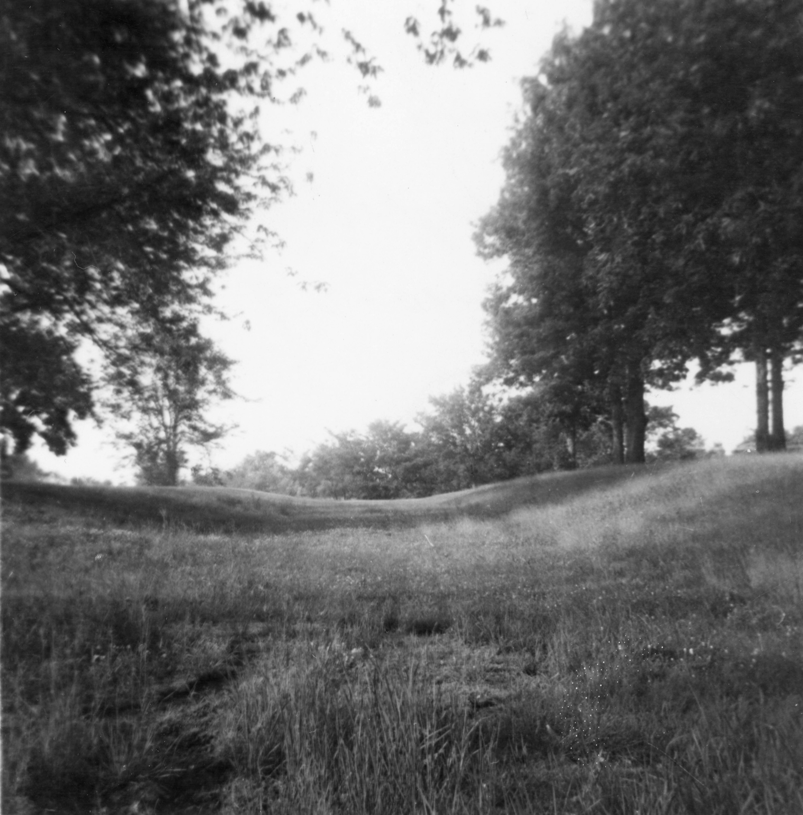
![A trace of the Boone’s Lick Road that was still visible in 1959, exact location unknown. [State Historical Society of Missouri, Hugh P. Williamson Photographs, P0468]](/sites/default/files/styles/article_header_image/public/2024-05/9.-boones-lick-road.jpg?itok=Jd4adLU7 "A trace of the Boone’s Lick Road that was still visible in 1959, exact location unknown. [State Historical Society of Missouri, Hugh P. Williamson Photographs, P0468]")
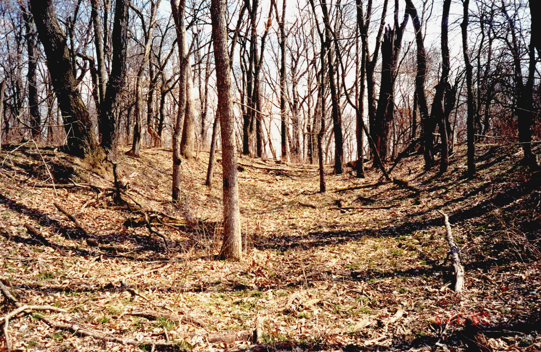
![A remaining trace of the Boone’s Lick alpha route in Boone County northeast of Rocheport, photographed in 1999. [Photo by Don Sanders, courtesy of David Sapp]](/sites/default/files/styles/article_header_image/public/2024-05/10.-boones-lick-road.jpg?itok=uf3V7pHW "A remaining trace of the Boone’s Lick alpha route in Boone County northeast of Rocheport, photographed in 1999. [Photo by Don Sanders, courtesy of David Sapp]")
The Boone’s Lick Road was the first major conduit to the trans-Mississippi West after the Louisiana Purchase in 1803. The Missouri River corridor was the logical starting point for Americans to exploit the riches of this massive acquisition, but traveling against the river’s current in the early 1800s was treacherous and too unpredictable for moving whole families and large amounts of goods. The Boone’s Lick Road, stretching almost 150 miles from St. Charles into Missouri Territory, became the main overland route for settlement and commerce. Two hundred years later, its progeny, Interstate 70, is a major US east-west transportation artery.
Development of the Road
The easternmost portion of what would become the Boone’s Lick Road was an extension westward from atop the common fields west of St. Charles, itself twenty miles west of St. Louis. Louis Blanchette’s 1769 settlement, originally called Les Petites Cotes, depended on the commons to survive. The road from the riverfront settlement to the fields followed Blanchette Creek to the west. By 1799 the road extended to Nicholas Kountz’s claim a few miles west of the fields and a mile east of present-day Cottleville.
A major leap westward was triggered in late 1804 when Nathan Boone and his brother-in-law, Mathias Van Bibber, came across saltwater springs, known as a salt lick, in what is now Howard County in central Missouri. James Mackay, however, had claimed the valuable saline a few years earlier as his reward from the Spanish for co-leading an expedition up the Missouri River. Boone and his brother, Daniel Morgan Boone, acquired rights from Mackay to extract salt from the waters of the lick, which came to be known as Boone’s Lick. Trips back and forth to the Boones’ home in the Femme Osage valley to the east necessitated finding the best overland route, for while their salt could be shipped downriver on shallow-draft boats, going upriver was arduous and risky.
Boone and others with interests in central Missouri sought the best route from the St. Charles extension west of Kountz’s to the Boone’s Lick region. In some places Native American trails or buffalo paths may have been incorporated. In general the route was determined by staying far enough north of the Missouri River to minimize the difficult traverses of its many north-south tributaries. At St. Charles and near the Boone’s Lick the route was alongside the river, but in other areas it ran twenty miles from the river.
The earliest known documentation of the general course that would become the favored route to the Boone’s Lick appears in the journal of William Clark compiled on a military expedition from St. Charles to establish Fort Osage in August and September of 1808. Clark’s unit of dragoons was guided by Nathan Boone. Past St. Charles, the only landmarks Clark could reference were water courses and the natural terrain, but it is clear they followed the general course that was soon being called the Boone’s Lick Road.
The US government was not yet prepared to permit land sales in the new territory because Native Americans still claimed much of it and no survey had been conducted. The Osage, Otoe-Missouria, and Illini all lived in eastern and central Missouri in the early 1800s, and they were all affected by the growth of the Boone’s Lick Road and the settlements it soon supported. By 1820 they had ceded most of their land claims in the area under pressure from the expanding white population.
The outbreak of the War of 1812 temporarily halted the flow of new settlers, as the area became unsafe for the few pioneer claimants to its land, and new claims were prohibited. Pressure nevertheless mounted to open the Missouri Territory to settlement. With the conclusion of hostilities in late 1815, it seemed no longer possible to hold back Americans demanding access to land. Settlers and land speculators began moving westward, mostly on the Boone’s Lick Road, to central Missouri and beyond, hoping to make preemptive claims. Many came from the states of the upper South, bringing with them a substantial enslaved population. Daniel Boone, his son Nathan, and most of the wealthiest landowners in the area were slaveholders. By 1820 the counties at the heart of the Boone’s Lick region, such as Howard, Boone, and Callaway, had slave populations between 12 and 15 percent of the total population. The percentage would continue to rise until the Civil War.
Shortly after the end of the War of 1812, President James Madison ordered a survey of the vast Louisiana Purchase. By mid-1816 a US survey team led by William Rector was systematically working in eastern Missouri north of the Missouri River. Their meticulous survey notes not only document early use of the “Boon’s Lick road” name but also provide a record of fifteen or more exact points on the road on either side of present Mineola in southern Montgomery County.
In a petition to Congress in December of 1817, the people of St. Charles referred to the road as the “light horse or Boons Lick road,” suggesting it was not quite a full “road” by their standards. Such a description is understandable when Missouri’s first state roads were required by early legislatures, with no state funding, to be “free of obstructions with stumps to be no higher than twelve inches.”
The years preceding and following statehood in 1821 brought thousands of Americans demanding new land. A great national migration westward added huge numbers to the locals using the road. Population data from the 1810, 1820, and 1830 federal censuses show a clear “finger” of more heavily populated areas jutting west from St. Louis and St. Charles into central Missouri mostly north of the Missouri River, as the Boone’s Lick Road became the most significant trans-Mississippi migration route in the United States at the time. In the ten years from 1820 to 1830, the state’s population more than doubled to about 140,000 people.
The road’s importance was communicated to the US Congress in November 1820 when the Missouri territorial delegation submitted a petition asking that a postal route be established “from the Town of St. Charles (now the Temporary seat of Government for this State) to the Town of Franklin in the County of Howard, on what is commonly called the old Boon’s lick road passing by Ja[mes] Journey’s, John Bevins, Isaac Vanbibbers, John Grayums and Augustus Thralls, to Franklin, and from thence if deemed expedient to continue the route on the most direct road generally travelled, crossing the Missouri river at the Arrow Rock by Mount Vernon to Fort Osage.” Senator Thomas Hart Benton added a note: “The route mentioned here is the direct route from St. Louis to the Boons lick country, and is certainly the route which should be established.”
Early Route Described
The road at the center of the Congress’s deliberations had not arisen from a single predestined route. Early trial-and-error explorations established the preferred routes for later travelers. Even so, although the citizens of St. Charles had their favorite local variations and vied for each to be made part of the main thoroughfare west, the primary route to the Boone’s Lick Country was fairly well set by the time hostilities from the War of 1812 eased in 1815. No early maps of the entire Boone’s Lick Road have survived, but two gazetteers from the early 1820s documented key stops on the road from St. Charles to Franklin.
A traveler starting in the heart of St. Charles around 1820 followed the course of Blanchette Creek and ascended the hills to relatively level high ground to the west. Another nine miles to the southwest roughly following the route of present-day Highway 94 brought them to Nicholas Kountz’s property, near what is now Cottleville, where Kountz and Missouri Rangers had erected a fort for protection during the War of 1812.
Twelve miles beyond Kountz’s, after passing through Dardenne Prairie, was Pond Fort, another private fortification used during the war years. Historian Kate Gregg wrote that when Missouri Rangers built the fort, they “established the early western objective of the Boonslick Road” on the claim of Malachi Baldridge. Pond Fort was located on the south side of present-day Route N about three and a half miles southeast of the intersection of I-70 and I-64. Ten miles farther to the west, Norman Pringle’s settlement, Hickory Grove, had formed around 1819 on the main road. Using present landmarks, it was about three miles south of Foristell on Route OO.
James Journey’s claim, settled by Roger Taylor, was the next identified stop about five miles west of Hickory Grove. Land records show that location to have been near what is now the intersection of West State Highway M and Route H about four and a half miles east of Warrenton, where John Bivins’s land was settled. Another six miles or so brought the wayfarer to Camp Branch Creek, about three miles east of present-day Jonesburg just south of I-70 on Old US 40.
For the next sixteen miles or so the Boone’s Lick Road followed almost exactly the current route of Interstate 70 before reaching the site of present-day Danville. One mile west of Danville was one of the most challenging river crossings of the trip, the Loutre River valley. Travelers in the 1820s could not simply assault the valley head-on the way I-70 drivers do today. They had to veer instead to the south, more or less following present-day Route J to Isaac Van Bibber’s at Loutre Lick (now Mineola). Most travelers probably rested at Van Bibber’s before beginning the ascent to the west following present Route N and I-70 for three or four miles until turning to the northwest along the route of what is now old US Highway 40. Less than two miles farther was another well-known resting place, Fruit’s. Alexander Fruit and his brother, Enoch, had settled just east of present-day Williamsburg by 1819.
The road continued in a northwesterly direction past John Ward’s and on to Aaron Watson’s on the edge of Grand Prairie, and from Watson’s to a crossing of the Auxvasse River at Auxvasse in Callaway County. A more direct westerly course roughly following the route of present-day Route E passed by Isaac Gearhart’s/Gayheart’s and crossed Cedar Creek into Boone County.
Benjamin Estill’s was about three and a half miles west of Cedar Creek on what is now Route H. From there the general westerly course crossed present-day US Highway 63 about one mile south of Hinton. Another challenging crossing faced the traveler two and a half miles farther west at the Roche Percee Creek (now Perche Creek). The steep bluffs on the west side of the valley could be managed if approached at an angle. Once across, the way led west to George Sexton’s on present O. B. Brown Road. Augustus Thrall’s, five miles onward, marked the last stop before entering Howard County.
Moniteau Creek at the Boone/Howard County line marked another challenging obstacle, and the hills in Howard County presented more difficulties. Most travelers wended their way west to Lucas’s or the better-known Arnold’s before turning southwest toward the Missouri River. From there they could, after 1816, stop at Franklin. From Franklin they could follow the river a short distance upstream and cross at Arrow Rock, or turn northward to the Boone’s Lick.
This early route—now sometimes referred to as the alpha Boone’s Lick Road—was well developed by 1820. It followed the terrain that best allowed pedestrians, horses, and, later, wagons to get to the desired area in Howard County. By 1820 the homes of some intrepid settlers had become guideposts for the traveler and were used as stage stops after a mail route was established. Some became known as taverns, or inns, where the traveler could stop as needed. Proprietors and landowners changed frequently, though, as the whole countryside was in a state of flux.
Changes to the Early Route
The formation of Callaway and Boone Counties in 1820 brought changes to the course of the main road into the heart of the state. Columbia, the Boone County seat, was more than six miles south of the main road and without other road access. Connecting roads became the first order of business. Better yet was to redirect the Boone’s Lick Road through the fledgling town. A point just west of Alexander Fruit’s residence in Callaway County was selected for a new, more westerly, course that was cleared to Columbia. By around 1822 much of the traffic on the road was using this newer route, now referred to sometimes as the beta route.
A county commission created by the legislature chose Elizabeth on the Missouri River as the first seat of Callaway County, only to establish a more central location in 1825 with the formation of Fulton. When that happened, a second significant change in the Boone’s Lick Road was made, with a more southwesterly course from Fruit’s into Fulton and then on to Columbia and beyond in what now may be called the gamma route.
Rerouting of the main road through Columbia and Fulton caused the course west of Columbia to also change, with the road moving closer to the Missouri River. Locals in Fulton and Columbia still referred to the new route as the Boone’s Lick Road. It was only this latest variation that was memorialized, with one exception, by the Daughters of the American Revolution in 1913 when they placed red granite markers along the early Boone’s Lick Road. The exception was a marker placed to commemorate the site of Thrall’s Prairie in western Boone County, a site on the earliest route.
Pushing on to Santa Fe
Although its name seems to suggest that the Boone’s Lick Road ended near the Boone salt lick, the way west extended beyond the lick well before the 1821 William Becknell expedition that led to the creation of the Santa Fe Trail. Exploitation of the lower Missouri River drove much of that travel, but the goal of more and more travelers became Santa Fe in New Mexico.
Exploratory trips to or from Santa Fe in the first decade of the 1800s usually kept to the Missouri River across Missouri until the river veered north. But some traders, such as Jacques Clamorgan and Manuel Lisa in 1807, used pack mules on the nascent Boone’s Lick Road and crossed to the south side of the river at Arrow Rock. The route from there westward to the Kansas River was an agreeable one. The following year Captain Nathan Boone led the St. Charles Company of Mounted Dragoons west past the salt lick to Fort Osage. Others kept going west on the road that extended past Boone’s Lick.
When the new Missouri Territory county of Howard was created in January 1816, it consisted of much of the northwest quadrant of the future state. Its population center was Boonville. By late 1816 the area was so desirable that the town of Franklin was laid out on the north bank of the Missouri River across from Boonville. Six months later the county seat was moved to Franklin. The designation brought a rapid influx of people to the town, including many educated and well-heeled citizens. Within three years the formerly empty field on the north bank of the river was occupied by hundreds of people.
Within a few years, the boomtown of Franklin thus became the outfitting point for Becknell’s famous expedition that left for Santa Fe on September 1, 1821, and returned in January 1822. Because of that, many now ascribe the start of the Santa Fe Trail to Old Franklin, just as it is often thought of as the nominal end of the Boone’s Lick Road. The settlement pressures and commerce that had been extended into central Missouri kept moving west following the lead set by the Boone’s Lick Road.
Parts of the original (alpha) route west of Williamsburg continued carrying local traffic even after the main route shifted through Fulton and Columbia. Other segments were fenced off, abandoned, or even plowed over. Today a few unimproved, short segments are still visible, mostly on private property. Much of the later (beta and gamma) route from St. Charles to Rocheport and into Howard County was incorporated into state and US highways as well as stretches of I-70. A detailed Google map of the routes of the Boone’s Lick Road is hosted on the website of the Boone’s Lick Road Association.
Boone’s Lick Road Association. www.booneslickroad.org.
Foley, William E. The Genesis of Missouri: From Wilderness Outpost to Statehood. Columbia: University of Missouri Press, 1989.
Gregg, Kate L. “The Boonslick Road in St. Charles County.” Missouri Historical Review 27, no. 4 (July 1933): 307–14 and 28, no. 1 (October 1933): 9–16.
Hurt, R. Douglas. “Seeking Fortune in the Promised Land: Settling the Boon’s Lick Country, 1808–1825.” Gateway Heritage 13, no. 1 (Summer 1992): 4–19.
Jackson, Hal. Boone’s Lick Road: A Brief History and Guide to a Missouri Treasure. Woodston, KS: Trails Press, 2012.
Lee, Robert. “The Boon’s Lick Land Rush and the Coming of the Missouri Crisis.” In A Fire Bell in the Past: The Missouri Crisis at 200, vol. 1, Western Slavery, National Impasse, ed. Jeffrey L. Pasley and John Craig Hammond, 77–112. Columbia: University of Missouri Press, 2021.
Morrow, Lynn. “Boone’s Lick in Western Expansion: James Mackay, the Boones, and the Morrisons.” Boone’s Lick Heritage Quarterly 13, no. 3–4 (2014): 4–32.
Schroeder, Walter A. “Spread of Settlement in Howard County, Missouri, 1810–1859.” Missouri Historical Review 63, no. 1 (October 1968): 1–37.
Published May 29, 2024; Last updated May 30, 2024
Creative Commons Attribution-NonCommerical-ShareAlike 4.0 International (CC BY-NC-SA 4.0)